Improving ecological knowledge of the region through data: the example of the L’Assomption RCM

Geographic data to support municipal decision-making
In the municipal sector, the quality of geographic data directly influences the ability to take action. Regional county municipalities (RCMs), like cities, rely on their cartographic databases to guide land use planning, prioritize the conservation of natural environments, and regulate development. When this data is up-to-date, accurate, and effectively utilized, it becomes a powerful tool for decision-making. Conversely, outdated or incomplete data can limit the effectiveness of decisions and interventions.
In a context marked by climate change, biodiversity loss, and evolving regulatory requirements, municipalities and regional county municipalities (RCMs) are called upon to play an increasingly important role in protecting natural environments and adapting their territories. To address these challenges, they must, in particular, gain a better understanding of the ecological functioning of their territories, identify strategic areas for conservation, and integrate this knowledge into their land-use planning processes.
Among the issues currently under the purview of the MRCs, the government’s land-use planning guidelines (OGAT) call on the MRCs to incorporate ecological connectivity, ecosystem resilience, and climate change adaptation into their practices. This requires not only access to high-quality, up-to-date data, but also the ability to translate that data into meaningful assessments and concrete actions.
This is whatHabitat set out to do in partnership with the L’Assomption RCM as part of the update and expansion of its Regional Natural Environment Plan (PRMN), which was originally developed by Habitat in 2021–2022.
Update the mapping of natural habitats to improve land-use planning
The approach is based on a simple yet fundamental principle: better understanding leads to better action. It is structured around three key steps:
Map updates
Ecological Analysis of the Region
Prioritizing interventions.
The first step involved a comprehensive update of the mapping of natural habitats. This step made it possible to incorporate recent data, particularly from LiDAR, satellite imagery, and eco-forestry inventories. The addition of detailed canopy mapping, including trees in urban areas, is a major contribution. Among other improvements made since the previous PRMN, Habitat refined the classification of wetlands to better distinguish open wetlands from forested wetlands.
This update has provided a more accurate picture of land use, revealing both recent changes in the landscape and ongoing ecological processes. It serves as a solid foundation for all subsequent analyses.
Ecological connectivity at the heart of the analysis
This updated map database was used to conduct a more in-depth analysis of the region’s ecological connectivity—one ofHabitat areas of expertise and a central concept in ecology for ensuring the sustainability of species and ecosystems. Indeed, in the long term, ecosystem degradation (e.g., fragmentation, urbanization, deforestation, pollution) and species disruption can reduce the ability of ecosystems to provide the ecosystem services essential to the well-being of the population.
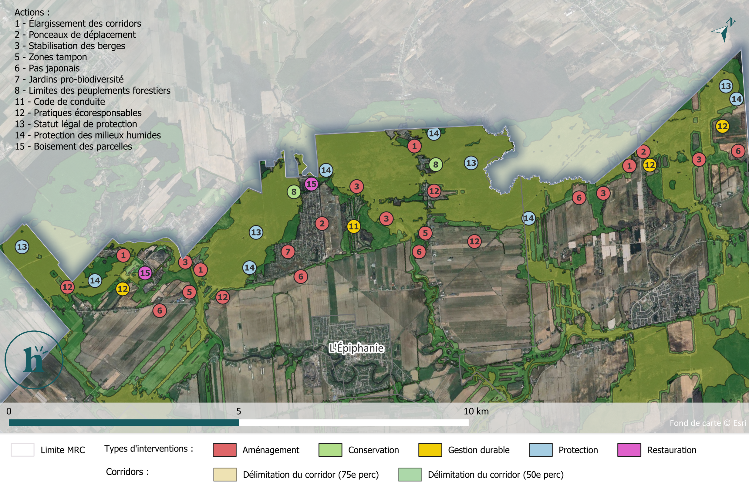
By combining several analytical methods and using key wildlife species as indicators, Habitat able to model and delineate the most important ecological corridors across the region. These analyses identified five major priority corridors connecting the main biodiversity hotspots. They also highlighted areas that are more fragmented, particularly by urban and agricultural development, as well as the key role of waterways and forested areas in maintaining connectivity.
Turning ecological analyses into concrete actions
One of the project’s key contributions lies in translating the analyses into concrete, immediately actionable recommendations tailored to local conditions.
Based on the prioritization of ecological corridors, specific actions have been identified and geographically targeted. These initiatives aim to address a wide range of issues, from the protection of natural habitats to the restoration of degraded areas, as well as the development of ecological corridors, the sustainable management of land use, and the engagement of local stakeholders.
These recommendations include, in particular:
Widening of riparian zones and bank stabilization;
The creation of wooded corridors in fragmented areas;
The installation of wildlife crossings under certain road infrastructure;
The adoption of agricultural practices that promote biodiversity;
The use of voluntary conservation mechanisms.
This integrated approach brings together a wide range of stakeholders—municipalities, conservation organizations, farmers, and citizens—to promote long-term implementation that is tailored to the diverse realities of the region.
The MRC now has a set of recommendations accompanied by monitoring indicators, which are useful both for the work of its internal teams and for its communication and public awareness efforts.
The analyses presented in this project can also inform other municipal initiatives, such as the development of a natural habitat conservation plan, the updating of a Regional Natural Habitat Plan (PRMN), the development of an ecological connectivity strategy, or urban forest planning.
Building Climate Resilience Through Urban Forests
Beyond ecological connectivity, the project places particular emphasis on the resilience of the region, notably through an analysis of the urban forest.
By studying the vulnerability of trees to climate-related threats (rising temperatures, ice storms, and flooding) and biological threats (insects and diseases), as well as the functional diversity of species, Habitat able to identify the areas most at risk within the MRC and direct planting efforts accordingly.
As a result of these analyses, the MRC now has detailed maps of the areas vulnerable to each of the threats studied. Combined with a list of tree species detailing their characteristics and conditions for success, these results provide a ready-to-use tool to guide future planting efforts and promote the development of a resilient urban canopy capable of continuing to provide essential ecosystem services to the population.
This detailed analysis makes it possible to move beyond a one-size-fits-all approach to greening and instead prioritize targeted planting initiatives tailored to local conditions and future climate risks. In this way, it helps to simultaneously enhance biodiversity, public comfort and health, as well as the region’s resilience.
These are precisely the factors driving the many initiatives currently underway in Quebec in the areas of sustainable land use planning, climate resilience, and biodiversity conservation.
Does your MRC or municipality want to update its mapping of natural areas, identify priority ecological corridors, or strengthen the resilience of its urban forest?